

Wellness in the Legal Profession
The Canadian Bar Association recently published a spotlight on wellness in the legal profession addressing a National Study about burnout. To combat stressors in the legal profession, the study published by Sherbrooke University, states that,
“[m]ost people are aware that the elements of a healthy lifestyle—such as a nutritious diet, restful sleep, physical activity and mindfulness exercises—play a role in reducing stress and, consequently, the onset of health problems. Adopting a healthy lifestyle also becomes more important when the workplace is home to multiple stressors.”
National Study about burnout (p. 239)
It is often difficult to realize when it is time to step away from work stressors and focus on your personal wellness. I do not have the ‘magic sauce’ to deal with these issues, but I wanted to share how I spent part of October working on my mental and physical health by hiking in France and Andorra – in the Pyrenees. For me, hiking and mountaineering is how I get ‘out of my head’, achieve clarity in thought and find direction despite having a busy and growing practice. Also, it forces me to put down my smartphone for a few hours.
Hiking the Pyrenees
For a little background, the Pyrenees span from the Atlantic to the Mediterranean and border France, Andorra and Spain. They are beautifully well-preserved and offer some of the most incredible breath-taking views I’ve ever seen.

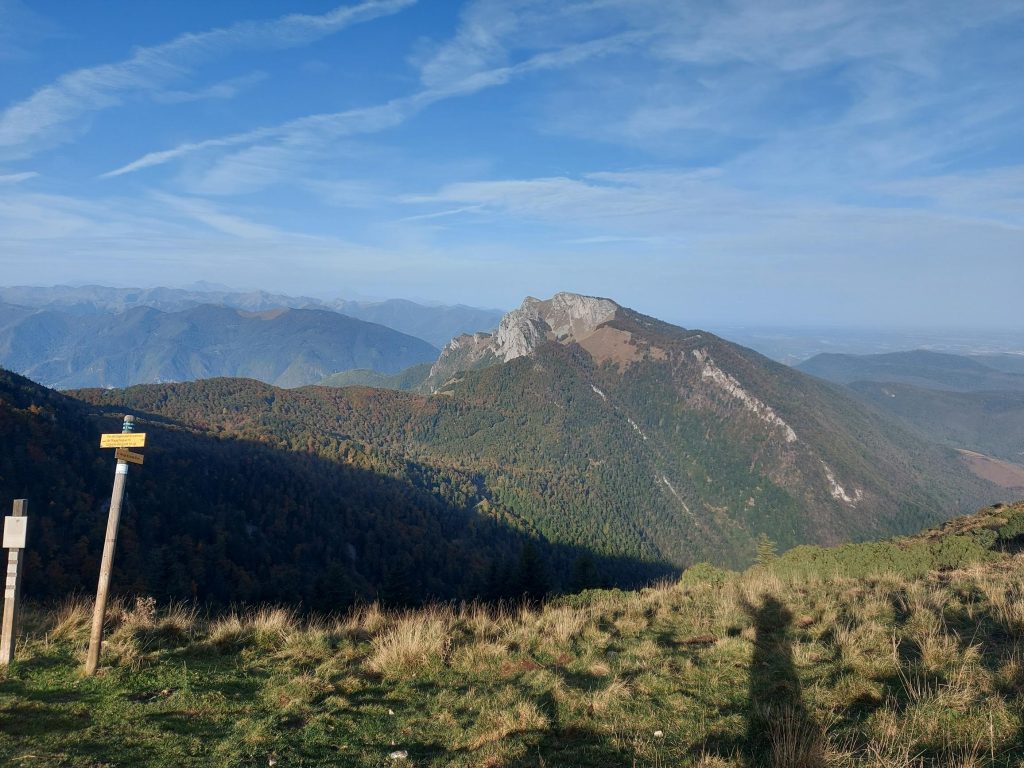
France – The Cagire Loop (Time to Complete: 4+ Hours, Distance: 11km+, Difficulty: Challenging)
This hike starts in Col de Mente (4,426 feet), France, and allows some of the most beautiful views of the Pyrenees. The hike ascends 4 different peaks and is physically challenging with a lot of uphill walking. While some blogs suggest the hike will take 4 hours, in my experience, this is an unrealistic timeline and the hike will take about 6 hours at a decent pace with a lunch break built in, which means, start early to give yourself enough time to complete it.
Starting-Off
 The starting point for the hike is across the street from the Auberge La Soulan. Once you’re ready to go, look for the black wooden hiker to lead you to the start of the trail on the right. It is an obvious gravel path that goes for about 1.4km and is the easiest part of the hike.
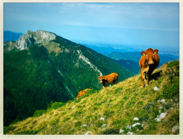
You will reach two buildings, the Refuge and Cabane de Larrieux (5,026 feet). Walk between the buildings until you reach a fountain and bench. The trail starts right behind a flag post with a cartoon illustration of one of the most dangerous things you will encounter on the hike, the Patou or the Pyrenean Mountain Dog. This fluffy bear-like dog blends in perfectly with the sheep they guard and won’t be noticeable at first but as you approach the herd, they become aggressive and follow you until you’re a good distance from the herd they’re protecting. Aside from watching your footing at all times, the most important thing I can stress is to not go near the sheep. This is not the time for selfies and this is not a petting zoo. Give a wide-berth and walk briskly. The dogs are scary and take their guard jobs very seriously.
The Start of the Trail
It is easy to get lost because the trail isn’t immediately obvious and veers in all directions, but if you continually watch for yellow and red path marks on the trees and rocks, you will find your way through the forest of pines to a massive uphill walk through the foothills of the mountains (North-East bearing). Here, the path becomes more obvious but always watch for the path markers.
The top of the path ends at the top of the foothills at an unnamed col. To the right is the Sommet de Pique Poque.
Pique Poque (6,227 feet) & Pic De Cagire (6,237 feet)
Probably the most fun to say of all peaks, the path to the Summit of Pique Poque is fairly straightforward. On route there is a grotto (a hole in the mountain). It is easy to miss though as the views from here of the Pyrenees are spectacular. The summit walk is only about an hour.
The Pic de Cagire is reached via Pique Poque. Just off the Pic de Cagire is La Croix du Cagire. A memorial that overlooks the valley de la Garonne. The internet suggests the Croix has been there since 1935 but when you’re there, it is impossible to imagine how its concrete structure got to those heights.
When leaving the Cagire summit, it is best to retrace your steps. My spouse and I used a few navigation tools and this is where the app, Alltrails, completely failed us (one of several instances). Sure, if you’re interested in burning out your legs and have loads of energy after this grueling hike up, there are more interesting paths back to the unnamed Col where we started, but the navigation app took us back walking along the side of a steep mountain on a sheep path. Just following the yellow and red tail markings and you’ll be less annoyed.
Sommet des Parets (6,132 feet) & Pic de l’Escalette (6,089 feet)
Back to the unnamed Col (where we first chose the path to the right), keep going straight to the Sommet des Parets. It’s muddy and slippery. While we were there in October, I read another blog that describes it much the same way, so it is likely like this for most of the year. Pole away and use your hands on this section as it is narrow in some parts. Climbers, rejoice – You will be in your element.

From the Sommet des Parets, it is an obvious path to Pic de l’Escalette. Again, there is some rocky scrambling to do to reach the summit, but worth every moment. On the summit, my spouse and I enjoyed a long lunch as we watched paragliders and birds of prey soar below us. We enjoyed our baguette and cheese and awed at the incredible views which included the Ski du Mourtis making us Ontarians long for access to bigger mountains.
This is where, again, the app failed us, big time. It took us on an unmarked non-path down requiring us to backtrack several times until we discovered that the path down simply requires retracing your steps down the Pic de l’Escalette to a trail between Pic de l’Escalette and Sommet des Parets. There is a very obvious trail, clearly marked that heads down. It’s not the most fun I’ve had going downhill. It is difficult (especially after backtracking) but eventually, you’ll get to the Cabane de l’Escalette. You will see this building in the distance and, in our case, there were sheep grazing which is where we met (and avoided as much as possible) the Patou. The steep path leads to a well-traveled dirt and then gravel road which is your ticket back to your car.
The End
The travelled road leads, eventually, back to the car. It is about 2km long. At this point, reflect on all you’ve accomplished in just this one day – 4 peaks and all the breath-taking views that will last a life-time. I highly recommend this hike.
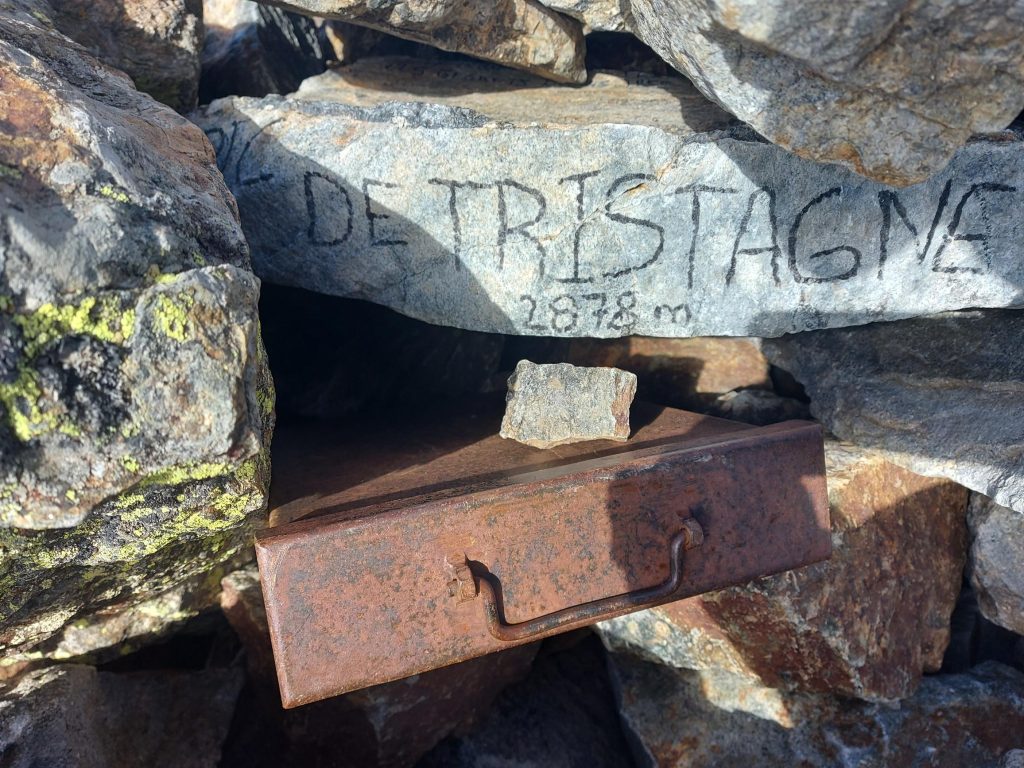
\”Andorra, I-Adore-Ya!\” – Summiting Pic de Tristaina (Time to Complete: 3.5 Hours, Distance: 8km, Difficulty: More Challenging in Parts)
The high-mountain Tristaina glacier lakes are a UNESCO bioreserve and one of the most popular hiking attractions in Ordino, Andorra. In fact, a gondola, brings tons of people from Ordino to the lake trails landing at the Ordino Arcalis Ski Resort – the start of the trail. Behind the lakes lies the Pic de Tristaina (9,442 feet), our hiking destination.

Starting-Off
Whether you take the gondola or drive, the starting point is just behind the restaurant, Coma d’Arcalis at the ski resort. There is a pole that guides you to the starting point and you are heading right.
The pathway is well-marked and well-traveled. Once you take the path over a rocky part, you will see the lakes of Tristaina with their crystal blue, clear glacier water. There are several lakes but the one you want to head for is right in front, Estany de Mes Amunt (to the left, a little lower) with the clouded Pic de Tristaina in the distance. Here, it doesn’t matter which path you take (right or left of the lake), just follow the markers and enjoy the grassy plateau walk.
The Foot of the Summit
The hike up the mountain starts on the right-side of the lake and it is signed with markers and cairns (or inukshuks to us Canadians). Head up the rocky path to the Port of Arbella – this is some strenuous hiking and it is important to note that the rocks are loose so use caution. It is advisable that hikers don’t hike above each other and be on the look-out for loose rocks that can fall.
Along the marked path, you will reach an exceptionally rocky part that requires some scrambling. Poles away for this part because it is challenging, steep and does require your hands and attention. While it is a few hundred meters in length, it can be exhausting and a little hairy if you are tentative of heights.
The Summit
At 9442.3 feet is the Pic de Tristaina summit. There’s an opportunity to sign a ‘guest book’ while admiring the breath-taking views. It’s fun to see the diversity of travelers and the countries they call home – all who converged on this peak.
Going down is sometimes more treacherous if you’re tired and after summiting there’s always a climber’s ‘high’ which means you’re thinking about how awesome that was and likely not paying much attention to anything else. On this hike, so long as you’re cautious while scrambling down the rocks, the rest is an easy decline back to the vehicle. We got back to our car just as the hoards of walkers were arriving from the gondolas to take-in the Tristaina lakes.
Conclusion – You\’re Worth It!
As lawyers, we internalize our client’s issues, work hard to meet targets and deadlines, and seek perfection in our jobs – this is all admirable – it means we care and are driven to success, but we often do this at the expense of our mental and physical well-being. I hope this blog inspires you to give yourself permission to put down your smartphone, spend a few days doing something you love, and focus on re-charging. You’re worth it.
